36 F. high in St. Cloud Friday.27 F. average high for February 17.
43 F. high a year ago, on February 17, 2011.
-11 F. coldest Twin Cities metro temperature this winter (MSP), tying for the 3rd warmest winter minimum in modern-day records.
3 subzero lows so far this winter. Average for KMSP is 28 nights below zero every winter.
7 subzero nights so far this winter at St. Cloud.
14 days at or above 40 since December 1 in St. Cloud.
+8.9 F. The first 16 days of February are running near 9 degrees warmer than average at St. Cloud.

10 hours, 30 minutes of daylight today.
104 minutes of additional daylight since December 21 in the Twin Cities.

.23" liquid predicted for the Twin Cities next Monday (NAM model). With temperature close to freezing I could see a mix of rain and snow ending as snow, a coating to an inch of slush possible Monday night on lawns and fields, while most main roads stay wet.
4X. According to Dr. Mark Seeley, midwinter rain and ice events have increased four-fold in the Twin Cities since 2000.
77 days of above average temperatures in the MSP metro area since November 1. Source: Dr. Mark Seeley. Details in his WeatherTalk blog below.
"Viewers tracking storms on television will perhaps most embrace the intelligence from the dual polarity that indicates whether or not a tornado has actually touched down. The key, Baron said, is that the dual polarity can identify the size of objects in the air - from large raindrops to small ones to even snow. And a common trait of a tornado on the ground is the debris it picks up. If there is a cluster of debris, that's a strong indicator of a touchdown." - from an article on dual polarization Doppler radar and Baron Services, a pioneer in radar technology, in a blog post at al.com below.

171 "Nexrad" (next-generation) National Weather Service Doppler radar systems across the USA, providing nearly continuous radar coverage from coast to coast. Map source: NOAA.

"Three states (Louisiana, Texas and South Dakota) have passed so-called Environmental Literacy Improvement Act bills — written by energy industry shills — that require schools to teach climate change "denial" along with conventional climate science. Other states are considering such measures." - from an article at salon.com below. Photo credit here.

"Research has shown that people are motivated to find information that supports their beliefs. "Encountering counterarguments causes us to marshal forces like an army of white blood cells to defend against them."
"Gallup and Pew polls show that the percentage of Americans that believe in climate change now hovers around 50 percent, but Krosnick's latest poll -- which asked the question in a more detailed way -- suggests the figure is 83 percent -- up from 79 percent in 1997. Of the global warming believers, the majority also reported thinking that the burning of fossil fuels and other human activities play a role. The trend held after the researchers broke the data down by political party: 66 percent of Republicans said climate change is happening." - from a Huffington Post article below.
20 cents/mile. Average cost of driving in a traditional, combustion-engine vehicle.2 cents/mile. Average cost of driving an EV, or electric vehicle. Source: Dept. of Energy, Tesla Corporation. Photo of Tesla Model S above courtesy of Wikipedia.
1.6 million elevators and escalators maintained by Otis Elevator Corporation, worldwide. A new generation of Otis elevators actually generates electricity, power that can go back into the building to keep the lights on. Source: Bloomberg Radio."The future belongs to those who believe in the beauty of their dreams." - Eleanor RooseveltDry Ponds And Green Grass In Eden Prairie. Thanks to WeatherNation meteorologist Susie Martin for sharing these photos of dry ponds and wetlands (and a lawn that's trying to green up - about 40 days ahead of schedule). I worry what will happen if we do see a spell of teens and 20s the end of February.
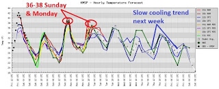
Above Average Temperatures Through Most Of Next Week. A cool Saturday (close to average for mid February) gives way to upper 30s Sunday and Monday, followed by a slow cooling trend the latter half of next week. Nothing arctic - but by the end of next week it may actually start to feel like February again.
Inside A Nearly Impossible Winter Weather Forecast. It's been an on-again/off-again storm for the Washington D.C. area. I can sympathize. The Washington Post's Capital Weather Gang describes the difficulty with Sunday's phantom snowstorm: "Last night (Thursday night), the models seemed to converging towards a snowy solution. It looked like there was a decent chance of meeting winter storm watch criteria. However, today's runs paint a different picture as there continues to be model chaos. Even the question of precipitation type has not been completely resolved. Why is this forecast so hard? It turns out, there are many layers of complexities involved. The overriding unresolved question is how much snow will the storm produce and, if it does, how much will stick. Both these questions are very much up in the air as very small changes in the storm track can make huge differences in the amount of precipitation it produces."* storm tracks and timing above courtesy of NOAA NCEP.


Latest Snowfall Prediction. The NAM is still printing out some 8-16" snowfall amounts for southeastern Kentucky and West Virginia, a plowable accumulation into central Virginia, with 1-3" possible for Washington D.C., a coating to 1" for Philly and south Jersey. Monday's (weak) storm over the Upper Midwest may drop a couple inches of slush on the Red River Valley, little snow expected in the Twin Cities metro area.

As Good As It Gets. A (warm), slow-moving and weakening area of low pressure may squeeze out a quick inch of slush Monday night, a better chance of a couple inches of snow over far western Minnesota. Models are hinting at another inch or so of snow next Thursday as temperatures begin to fall. Nothing but (meager) clippers. Yes, we are most definitely in a snow recession.


I've meant for some time to develop a good reason for having a personal letterhead.